Trail 4x4 Le Mayet-de-Montagne - le mayet la prune. - Photo
© OpenStreetMap contributors
Length
Length
21 km
Max alt
Max alt
958 m
Uphill gradient
Uphill gradient
849 m
Km-Effort
Km-Effort  
32 km
Min alt
Min alt
547 m
Downhill gradient
Downhill gradient
706 m
Boucle
Boucle
No
Creation date :
2019-07-14 11:52:28.643
Updated on :
2019-07-17 14:07:06.704

(1 Reviews)

4x4
4x4
3h27
Difficulty : Easy

Scan this QR Code to open this trail in the SityTrail application

FREE GPS app for hiking

Logo SityTrail SityTrail

IGN / Geographical institutes

Download SityTrail from the App Store Download SityTrail from Google Play

Logo SityTrail SityTrail World

The world is yours!

Download SityTrail from the App Store Download SityTrail from Google Play Download SityTrail on Huawei AppGallery

About

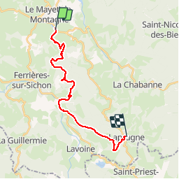
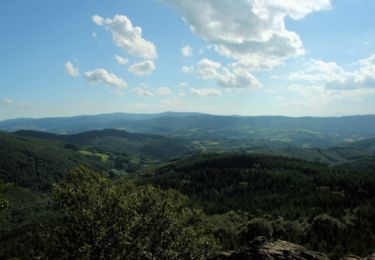
Trail 4x4 of 21 km to be discovered at Auvergne-Rhône-Alpes, Allier, Le Mayet-de-Montagne. This trail is proposed by terminatoy.

Elevation profile

Positioning

Country:
France
Region :
Auvergne-Rhône-Alpes
Department/Province :
Allier
Municipality :
Le Mayet-de-Montagne
Location:
Unknown
Start:(UTM)
552077 ; 5100899 (31T) N.

Comments

Please log in to post a review or rate the element


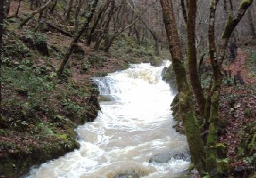
portion pas adapté pour un Toyota Land cruiser long plutôt adapté pour un 4x4 préparer avec full protection quel dommage


Trails nearby

Trail Walking Ferrières-sur-Sichon - Balade autour de Ferrières sur Sichon - Photo
Walking
tracegps

Walking

Medium
(1)
Ferrières-sur-Sichon, Auvergne-Rhône-Alpes, Allier, France
7.4 km | 10.8 km-effort
2h 15min
Yes
Trail Walking Châtel-Montagne - Charguéraud a La Croix Bruyère  - Photo
Walking
NANE51

Walking

Easy
Châtel-Montagne, Auvergne-Rhône-Alpes, Allier, France
12.2 km | 16.9 km-effort
3h 9min
No
Trail Walking Le Mayet-de-Montagne - Saint Clément - Photo
Walking
tracegps

Walking

Difficult
Le Mayet-de-Montagne, Auvergne-Rhône-Alpes, Allier, France
15.9 km | 23 km-effort
3h 30min
Yes
Trail Walking Le Mayet-de-Montagne - Le Grand Roc - Le Mallot - Photo
Walking
tracegps

Walking

Medium
Le Mayet-de-Montagne, Auvergne-Rhône-Alpes, Allier, France
10.4 km | 15.2 km-effort
2h 45min
Yes
Trail Walking Le Mayet-de-Montagne - Boucle autour du Cluzel - Arronnes - Photo
Walking
tracegps

Walking

Medium
Le Mayet-de-Montagne, Auvergne-Rhône-Alpes, Allier, France
12 km | 15.8 km-effort
2h 45min
Yes
Trail Walking La Chabanne - Balade autour de Chaudagne - Photo
Walking
tracegps

Walking

Medium
La Chabanne, Auvergne-Rhône-Alpes, Allier, France
8 km | 11.1 km-effort
2h 0min
Yes
Trail Horseback riding Le Mayet-de-Montagne - saint clement 03250 30 kms - Photo
Horseback riding
pugnet

Horseback riding

Difficult
Le Mayet-de-Montagne, Auvergne-Rhône-Alpes, Allier, France
28 km | 39 km-effort
7h 34min
No
Trail Quad Ferrières-sur-Sichon - rando - Photo
Quad
cdecloitre

Quad

Very easy
Ferrières-sur-Sichon, Auvergne-Rhône-Alpes, Allier, France
72 km | 103 km-effort
5h 17min
Yes
Trail Walking Ferrières-sur-Sichon - 22286 - Photo
Walking
betf

Walking

Very difficult
Ferrières-sur-Sichon, Auvergne-Rhône-Alpes, Allier, France
14.3 km | 21 km-effort
4h 42min
Yes


Close
My subscriptions